Where did people find water in the desert? A very archaeological question. Janet's
young grandson Alex has kept me busy on and off over the last few
months with lots of questions about desert geology, geomorphology and
related subjects, about which I am anything but an expert. They are
really good questions. Alex’s most recent questions, which will
be dealt with one at a time, include this one about how people found
water in the desert. The following explanations are very sweeping,
ironing out the complexities, but hopefully they cover the main areas.
Today the Western
Desert is hyper arid, which generally means an area that receives less
than 100mm rainfall per year. In fact, the Western Desert receives less
than 10mm a year. That’s too dry to herd domesticated animals or to
support large herds of herbivores without alternative water sources. It
is far too dry to support any form of cultivation. Following the end
of the last ice age, from around 10,000BC onwards, conditions were much
wetter. Climate changes at that time included the shift of a much
wetter climatic front (called the Inter-Tropical Convergence Zone or
ITCZ) to the north. This brought summer rainfall and converted the
desert from hyper-arid to semi-arid (between 250-500mm rainfall per
year). This is still dry but supports savannah and Sahel type
conditions, with sufficient rainfall to support various wild grasses,
shrubs and other vegetation. This vegetation, in turn, attracted
herbivores, and in their wake carnivores including human populations.
This early post-glacial period is known as the early Holocene in
climatic terms. Archaeologically, it is usually referred to as the
Epipalaeolithic and early Neolithic, a hunting and foraging phase during
which people were either fully mobile or only partially mobile due to
the favourable conditions. The ITCZ started to return south, taking
with it rainfall, inaugurating the middle Holocene, and rainfall regimes
changed, with lower levels of summer rainfall. But at the same time
winter rainfall became available. Conditions were not good enough to
support even partial sedentism and people were fully mobile, but by this
time sheep and goat had been introduced from the Near East and cattle
had been domesticated locally.
So to answer Alex’s question,
where did the water come from? It came from three sources: rainfall
from above, the Nubian aquifer from below and, in the case of the
Faiyum, a run-off channel from the Nile.
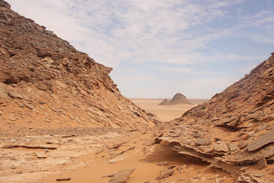
 |
Rock art from the Gilf Kebir. Today the area is hyper-arid but
1000s of years ago there was sufficient water to support life |
As described above,
rainfall was available in the early and mid Holocene. Although some
animals, like gazelle, can take their total moisture intake from leaves,
people and most animals need water in liquid form, and fairly
substantial amounts of it. This means that they have to become experts
on finding sources of water, or in other words, the places where
rainfall gathers into lakes and pools. I will give two examples from
the Western Desert. The first are the so-called playa lakes, the best
known of which are the ones that formed at Nabta. These are depressions
in the sand in which rainfall gathers. They are big enough to support
visiting people, who included the playa lakes in their regular seasonal
travels through the savannahs of the Western Desert. Herbivores and
domesticated herds require both water and pasture, so those two
resources are a very strong influence on how people made decisions on
where and when to move. Fortunately, many of these water sources
filled predictably year after year so people could factor them into
their routine movements. Water evaporates quickly under conditions of
high heat, so the playa lakes dried up and people had the option of
digging down to follow the water via wells before moving on. Sand,
surprisingly, has great water retaining properties, so wells are always
an option where the sand remains saturated.
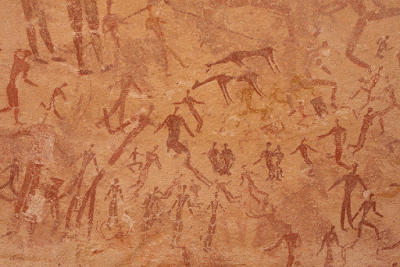
Another source of
rainfall storage were dune lakes. This is confined to the highland area
known as the Gilf Kebir. The Western Desert lacks highland areas, but
the Gilf Kebir is a high plateau at the far southwest of the Western
Desert. Highland areas attract additional rainfall, so are often
attractive for hunters and herders in their seasonal round. The plateau
of the Gilf Kebir is incised by multiple wadi (dry river valley)
systems, and across several of these sand dunes formed, creating
barriers across the valleys. When the rains fell, the waters were
trapped behind the dunes, creating deep lakes. Like the playa lakes
described above, they lasted through the early and mid Holocene periods.
Again, there is a lot of archaeology associated with the dune lakes,
which were visited for several 100 years.
 |
| An artist's impression of Dakhleh Oasis in prehistory. |
The other main source
of water was the Nubian aquifer. This is an underground reservoir that
lies beneath Egypt, the Sudan, Chad and Libya. The aquifer is an
extraordinary thing. The waters are contained within sandstones that
are porous and can hold water and in places has been exposed by erosion,
allowing the waters contained in the sandstone to filter out of it into
surrounding dips and basins. The waters don’t drain out of the
sandstone at its base because impermeable layers lie beneath it and over
it, preventing the water escaping from the sandstone, effectively
containing it. The aquifer was filled during wetter periods and it is
thought that it is no longer replenished. A series of large and small
oases dot the Western Desert. These are depressions in the desert where
the aquifer reaches the surface in the form of springs and can form
ponds and small lakes. This was a year-round resources so was obviously
of fundamental importance to people and animals. At times of drought
and when the climate began to change permanently at around 5300BC, these
became refuges where people could gather. Naturally this aggregation
will have had its own problems associated with it, as unusual
concentrations of people always carry risks to resources and social
relationships. Kharga, Dakhleh and Bahariya oases were used throughout
the Pharaonic periods and supported large Ptolemaic and Roman
communities. Today the water is sufficient to support several large
agricultural communities within the oases, with the assistance of modern
wells and pumps, although as a source of fossil waters there are
concerns that this may not be a renewable resource.
 |
| The Eastern Desert |
Although I
have been talking mainly about the Western Desert, the Eastern Desert
was also an important home to people in prehistory, although it is much more
difficult to assess due to the natural destruction of archaeological
remains and the restrictions on archaeological research due to the
status of much of the Eastern Desert as a military zone. Unlike the
Western Desert, the Eastern Desert is still occupied by Bedouin today,
herders of camel, sheep and goat. The Red Sea Hills attract rainfall,
and although most of this drains to the east, sufficient falls over and
drains into the Eastern Desert hills to flow down wadis and gather in
wadi bottoms and in stone basins. The Nubian aquifer flows under the
Eastern Desert too, but is much deeper below the surface and is less
easy to access, although it does come to the surface at certain points.
Today’s Bedouin groups, who roam the entire Eastern Desert, are experts
at sourcing the water and making the most of it, even cultivating small
horticultural plots when there is sufficient saturation of the ground
to permit it. Although there is not much archaeology left on the
ground, having been swept away due to erosion and flash floods, the rock
art attests to a time when the desert was used during the Predynastic
period. Today, the Ma’aza Bedouin clans that occupy part of the
Egyptian Eastern Desert have a large vocabulary that describes different
types and degree of water source, including “dripping places” where
water drips permanently to feed a permanent colony of ferns, reeds and
mosses and permanent pools of water, wells that are dug by hand, gravel
seeps, springs, rain-fed rock basins (which may last only a few days or
up to several years), rainfall run-off pools and a permanent pool, the
origins of which are unknown. Water sometimes has to be carried to
herds.
 |
The Faiyum Depression showing the rich vegetation provided
by the lake, and the desert beyond. |
Finally, there is an enormous lake today to the
southwest of Cairo, the heart of the Faiyum Depression, now 45m below
sea level. It was much bigger in the past and a lot of research has
been done into the various levels that it reached at different times.
It is notable for being the home of Egypt’s earliest known agriculture
in prehistory, and before that was occupied by various hunting and
foraging groups. Unlike the other Western Desert water sources, it was
fed from the river Nile via a small off-shoot of the river called the
Bahr Yusef, which ran parallel to the Nile from just north of Asyut
before branching off and filling the depression in which the lake sits
today.
From a human point of view, the task was for people to go
to where the water was to be found, not to wait for the water to come to
them. Water can be stored, of course, and carried over short
distances, and this requires vessels, like pottery, carriers made of
animal hides and animal innards, ostrich shell and natural stone basins,
but it doesn't last long and a new source will have to be found. A
whole series of livelihood strategies grew up around this essential
requirement, of which mobility was the main form of flexibility.
I


Comments